Table of Contents
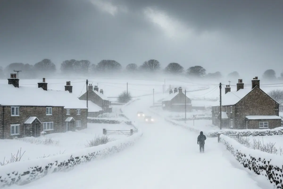
Storm Goretti has become a major trending topic across the United Kingdom. The powerful winter storm is expected to bring heavy snowfall, strong winds, and widespread disruption. Weather agencies have issued multiple warnings as the system moves in from the Atlantic. Millions of people may face travel problems, school closures, and dangerous conditions over the next 48 hours.
What Is Storm Goretti?
Storm Goretti is a fast-developing low-pressure weather system forming over the Atlantic. It has been named under the European storm naming system due to its expected impact. The storm is forecast to strengthen quickly as it approaches the UK, pulling in cold Arctic air and moisture at the same time.
This combination increases the risk of heavy snow, ice, and damaging winds across many regions.
Why Storm Goretti Is So Dangerous
Storm Goretti is developing rapidly, a process known as explosive cyclogenesis. This happens when air pressure drops very quickly over a short time. Rapid pressure drops create stronger winds and heavier precipitation.
Cold air already sits over much of the UK. As milder, wet air pushes in, rain can quickly turn to snow. This makes forecasts harder and increases risk.
Weather Warnings Across the UK
Amber and yellow weather warnings are in place across large parts of the country. These warnings highlight a risk to life and property.
Amber Warnings
- Heavy snow in Wales, the Midlands, Yorkshire, and parts of southern England
- Strong winds in parts of the South West, including coastal areas
Yellow Warnings
- Snow and ice across England, Scotland, Wales, and Northern Ireland
- Wind warnings for southern and eastern regions
- Rain warnings in parts of eastern England
These alerts mean delays, cancellations, and possible power outages.
Snowfall and Wind Forecast
Storm Goretti is expected to deliver severe winter weather.
- Snowfall of 15 to 30cm is possible in parts of Wales and the Midlands
- Higher ground may see even deeper accumulations
- Wind gusts could reach 80 to 90mph in exposed coastal areas
- Blowing snow may reduce visibility to near zero
Snow will begin on higher ground, then spread to lower areas overnight.
When Will Storm Goretti Hit?
The storm will affect the UK in stages.
- Thursday afternoon: Rain spreads north and east, winds increase
- Thursday evening: Snow develops as temperatures drop
- Overnight: Heaviest snowfall and strongest winds
- Friday morning: Ongoing disruption before conditions slowly ease
Small shifts in temperature could change rain to snow quickly.
Travel Disruption Expected Nationwide
Storm Goretti will heavily impact transport networks.
Road Travel
Snow and ice will make roads hazardous. Drifting snow may block routes. Authorities advise against non-essential travel. Gritting may struggle in extreme conditions.
Rail Services
Train delays and cancellations are expected across England, Scotland, and Wales. Snow on tracks and wind damage to power lines may affect services.
Air Travel
Some flight delays and cancellations are likely. Smaller airports and island services face higher risk during peak winds.
School Closures and Work Disruption
More than one thousand schools have already closed due to cold and icy conditions. Storm Goretti may force many more to shut.
Schools decide locally based on safety, access, and transport. Parents may need to arrange childcare or remote learning.
Employees may have legal rights to time off for dependent care, depending on employer policy.
Health and Safety Risks
Severe winter weather increases health risks.
- Slips and falls on icy surfaces
- Road accidents due to low visibility
- Cold exposure for elderly and vulnerable people
- Power cuts affecting heating systems
Local councils and charities are opening warm spaces for those in need.
How Communities Are Responding
Across affected regions, communities are helping each other. People are checking on neighbors, sharing supplies, and clearing snow. Emergency services remain on high alert.
Retailers in snowy areas report high demand for sleds, heaters, and winter supplies.
Storm Goretti Overview Table
| Aspect | Details |
|---|---|
| Storm Name | Storm Goretti |
| Main Hazards | Heavy snow, strong winds, ice |
| Snowfall Range | 15–30cm in affected areas |
| Wind Speed | Up to 90mph in exposed locations |
| Most Affected Areas | Wales, Midlands, Yorkshire, South West |
| Weather Alerts | Amber and Yellow warnings |
| Transport Impact | Road, rail, and flight disruption |
| School Closures | 1,000+ and rising |
| Storm Duration | Thursday evening to Friday |
How to Stay Safe During Storm Goretti
- Check weather updates regularly
- Avoid unnecessary travel
- Drive slowly and carry emergency supplies
- Keep phones charged
- Check on elderly or isolated neighbors
- Follow local authority advice
Preparation can reduce risk.
Final Outlook
Storm Goretti is one of the most serious winter weather events this season. Heavy snow, high winds, and freezing temperatures will combine to disrupt daily life across the UK. The situation remains fluid, and conditions may change quickly.
Staying informed and cautious is essential over the coming days.